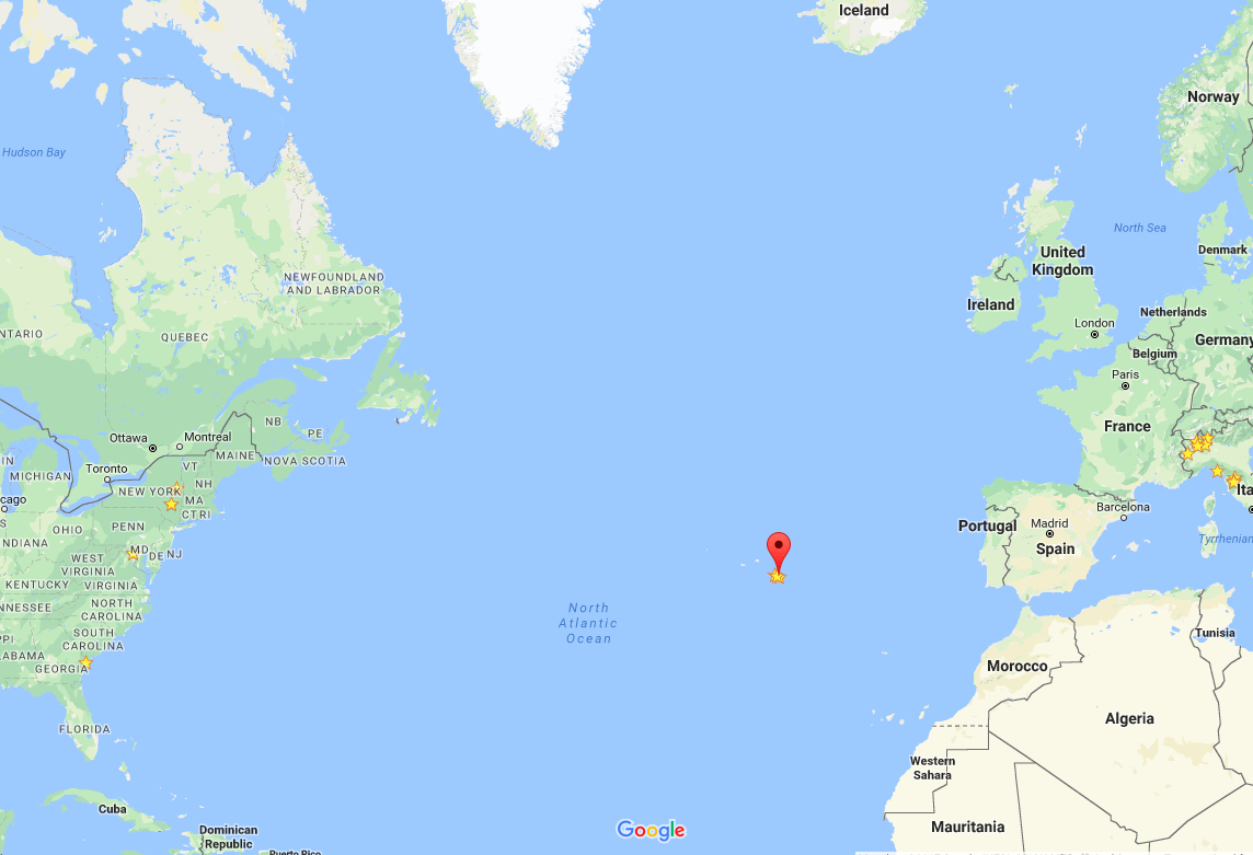
In the middle of the Atlantic Ocean
Below is a click on interactive Google Map you can use to see more detail and navigate around. For us, it will be a 4:45 direct flight from Boston to Sao Miguel, four time zones away.
AzoresFrom Wikipedia, the free encyclopedia
This article is about the archipelago. For the area of high pressure, see Azores High. Azores (Açores) Autonomous Region (Região Autónoma) Mount Pico and the green landscape, emblematic of the archipelago of the Azores Flag Coat of arms Official name: Região Autónoma dos Açores Name origin: açor, Portuguese for species of raptor, erroneously identified as goshawks; also derivation from the word for blue Motto: Antes morrer livres que em paz sujeitos (English: "Rather die as free men than be enslaved in peace") Country Portugal Autonomous Region Azores RegionAtlantic Ocean SubregionMid-Atlantic Ridge PositionAzores Platform IslandsCorvo, Faial, Flores,Graciosa, Pico, São Jorge,São Miguel, Santa Maria,Terceira MunicipalitiesAngra do Heroísmo,Calheta, Horta, Lagoa,Lajes das Flores,Lajes do Pico, Madalena,Nordeste, Povoação,Praia da Vitória,Ponta Delgada,Ribeira Grande,Santa Cruz da Graciosa,Santa Cruz das Flores,São Roque, Velas,Vila do Corvo, Vila do Porto,Vila Franca do Campo CapitalPonta Delgada[1] Largest cityPonta Delgada - centerSão José - elevation22 m (72 ft) - coordinates37°44′28″N 25°40′32″WCoordinates: 37°44′28″N 25°40′32″W Highest pointMount Pico - elevation2,351 m (7,713 ft) - coordinates38°28′19″N 28°51′50″W Lowest pointSea level - locationAtlantic Ocean - elevation0 m (0 ft) Area2,333 km2 (901 sq mi) Population245,746 (2012) Census 2011 Density105.87/km2 (274/sq mi) Settlement15 August 1432 - Administrative autonomyc. 1895 - Political autonomy4 September 1976 Discoveryc. 1427 - Santa Mariac. 1427 - São Miguelc. 1428 Management - locationAssembleia Regional, Rua Marcelino Lima, Horta, Faial - elevation46 m (151 ft) - coordinates38°32′6″N 28°37′51″W Government - locationPalácio de Santana, Rua José Jácome Correia, Ponta Delgada, São Miguel - elevation60 m (197 ft) - coordinates37°44′52″N 25°40′19″W President (Government)Vasco Cordeiro (PS) - President (Assembleia)Ana Luís (PS) TimezoneAZOT (UTC−1) - summer (DST)AZOST (UTC) ISO 3166-2 codePT-20 Postal code9XXX-XXX Area code(+351) 29X XX XX XX[2] ccTLD.pt Date formatdd-mm-yyyy Driveright-side DemonymAzorean Patron SaintEspírito Santo Holiday51st day (Monday) following Easter (Dia da Região Autónoma dos Açores) AnthemA Portuguesa (national) Hino dos Açores (regional) CurrencyEuro (€)[3] GDP (nominal)2013 - Total€ 3,694 million[4] - Per capita€ 14,900[4] Location of the Azores relative to Portugal (green) and the rest of the European Union (dark blue) Distribution of the islands of the archipelago Wikimedia Commons: Azores Statistics: Instituto Nacional de Estatística[5] Website: www.azores.gov.pt Geographic detail from CAOP (2010)[6] produced by Instituto Geográfico Português (IGP)The Azores (/əˈzɔərz/ ə-ZOHRZ or /ˈeɪzɔərz/ AY-zohrz; Portuguese: Açores, [ɐˈsoɾɨʃ]), officially the Autonomous Region of the Azores(Região Autónoma dos Açores), is one of the two autonomous regions of Portugal, an archipelago composed of nine volcanic islandsin the North Atlantic Ocean about 1,360 km (850 mi) west of continental Portugal, about 1,643 km (1,021 mi) west of Lisbon, in continental Portugal, about 1,507 km (936 mi) from the African coast, and about 1,925 km (1,196 mi) southeast of Newfoundland, Canada. Its main industries are agriculture, dairy farming, livestock, fishing, and tourism, which is becoming the major service activity in the region. In addition, the government of the Azores employs a large percentage of the population directly or indirectly in the service and tertiary sectors. The main settlement of the Azores is Ponta Delgada. There are nine major Azorean islands and an islet cluster, in three main groups. These are Flores and Corvo, to the west; Graciosa, Terceira, São Jorge, Pico, and Faial in the centre; and São Miguel, Santa Maria, and the Formigas Reef to the east. They extend for more than 600 km (370 mi) and lie in a northwest-southeast direction. All the islands have volcanic origins, although some, such as Santa Maria, have had no recorded activity since the islands were settled. Mount Pico, on the island of Pico, is the highest point in Portugal, at 2,351 m (7,713 ft). If measured from their base at the bottom of the ocean to their peaks, which thrust high above the surface of the Atlantic, the Azores are actually some of the tallest mountains on the planet. The climate of the Azores is very mild for such a northerly location, being influenced by its distance from the continents and by the passing Gulf Stream. Due to the marine influence, temperatures remain mild year-round. Daytime temperatures normally fluctuate between 16 °C (61 °F) and 25 °C (77 °F) depending on season.[7][8] Temperatures above 30 °C (86 °F) or below 3 °C (37 °F) are unknown in the major population centres. It is also generally wet and cloudy. The culture, dialect, cuisine, and traditions of the Azorean islands vary considerably, because these once-uninhabited and remote islands were settled sporadically over a span of two centuries.
0 Comments
Leave a Reply. |
ArchivesCategories
All
My Flickr Images Tagged "Azores"
Authors/
|

 RSS Feed
